Artifacts & Shipwrecks Contents Artifacts Contents Shipwrecks ... Objects ... Gallery of Ships ... Materials ... Miscellaneous ... Artifacts & Shipwrecks Contents Shipwrecks Wooden Ship Construction Iron & Steel Ship Construction Anchors & Chain Capstans & Winches Boilers Engines Propellers, Shafts & Rudders Paddlewheels Bits & Cleats Masts Objects Arrowheads Bottles China & Silverware Deadeyes & Blocks Disco Ball Engine Telegraph ha ha ha Portholes & Deck Lights Traps & Dredges Gallery of Ships Barge Ferry Fishing Vessels Commercial Fishing Ports Trawlers ("Draggers") Clam Dredges Purse Seiners & Gill-netters Scallop Dredges Long-liners Lobster Boats Charter Fishing Boats Fish Traps Freighter Lightship Liner Pilot Boat Sailing Ships Schooner Barge Steamer or Steamship Submarine Tanker Tugboat McAllister Towing & Transportation Moran Towing Company Warship Materials Metallurgy Iron, Steel & Rust Copper, Brass & Bronze Miscellaneous Metals Wood & Organic Materials Glass & Ceramics Rock & Stone Polymer Materials Density & Specific Gravity Miscellaneous Collision at Sea Conservation of Artifacts Glossary of Terms Distance & Navigation Side-scan Sonar Wire Drag Captain George Hoffman Searching For Shipwrecks All About Artifacts Identifying The Emerald Maritime Salvage Law Nautical Signal Flags Artifacts References
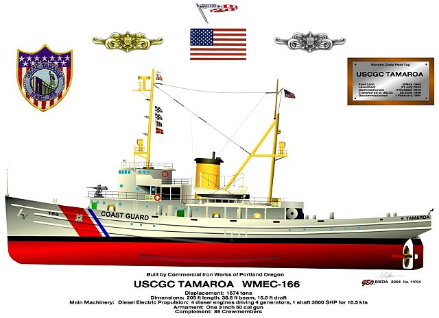
Tamaroa WMEC-166 Type: artificial reef, fleet tugboat, cutter Built: 1943, Commercial Iron Works, Portland, OR, as USS Zuni AT-95 Specs: ( 205 x 38 ft ) 1,235 tons (light) Sunk: Wednesday, May 10, 2017 - DelJerseyLand Artificial Reef GPS: 38°31.144' -74°30.747' Depth: 125 ft More: Tamaroa WMEC-166 ...